Standard Products / Derivative-work Products
ALOS Standard Products are offerd at reasonable prices.
| Offer Method |
CD-R or DVD-R |
| Shipping |
About 3 days from order date |
Standard Products
| AVNIR-2
|
Level 1A |
Uncorrected data cut out in scene |
| 1B1 |
Radiometrically calibrated data |
| 1B2 |
Geometrically corrected data
R Geo-reference
G Geo-coded
D Rough DEM correction(Japanese area) |
| PRISM |
Level 1A |
Uncorrected data cut out in scene |
| 1B1 |
Radiometrically calibrated data |
| 1B2 |
Geometrically corrected data
R Geo-reference
G Geo-coded |
| PALSAR |
1.0 |
Uncorrected data cut out by scene |
| 1.1 |
Range and azimuth compressed data on slant range |
| 1.5 |
Multi-look processed image projected to map coordinate
R Geo-reference
G Geo-coded |
Click here for sample data
ALOS Viewer
RESTEC has developed The ALOS viewer. You can download it below.
This viewer's functions are not only to display the pictire but to
measure distance and area, and to show the range of the picutre on the map.
ALOS Viewer (ZIP file:7.62MB)
Derivative-work Products / Service
| Format transformation Service |
Conversion service to GeoTIFF or NITF |
 TOP
TOP
Value Added Products
| Ortho-Light |
Ortho-rectified image corresponding to GSI map scale 1/25000 (Japan Area Only)
(provision start on January 24, 2007) |
| Pan-sharpen |
Pan-sharpen image by PRISM and AVNIR-2 (provision start on January 24, 2007) |
| Mosaic |
Mosaic Image |
| Sub mesh |
The second mesh cut-out of Ortho-Light |
Pan-sharpend images
Field Area
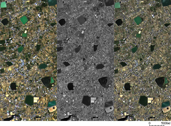
AVNIR-2:10m resolution
PRISM:2.5m resolution
Pan-sharpen:2.5m resolution |
|
Urban Area
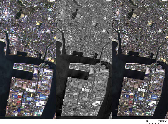
AVNIR-2:10m resolution
PRISM:2.5m resolution
Pan-sharpen:2.5m resolution |
TOP
On-demand Products
Products listed below are available on request basis. Related service is also available on request.
Examples of On-demand Products
| On-demand Products |
Additional data with vector information |
With vector information of administration area lines |
| |
Cutting out service of requested area |
City, Town, Village, or Prefecture basis etc |
| |
3D Image |
Bird’s eye view etc. |
| |
Movies |
Quick-time movies. Panorama etc. |
| Analysis Service |
Vagetation Index data |
NDVI、Texture detection |
| |
Thematic Data |
Vegetation, Classified tables etc, Land Coverage |
| |
Alteration Extracted Data |
Urban Development, Finding environment change |
| |
SAR Interferometry |
Stripe Interference, Extraction of DSM data |
Consultation and
user-support |
Work support |
Carrying out support work suitable for users needs |
TOP