PRISM Panchromatic Remote-sensing Instrument for Stereo Mapping
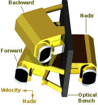
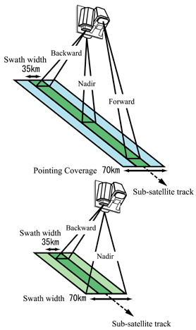
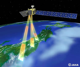 “PRISM” has three independent optical systems for viewing nadir, forward and backward producing a stereoscopic image along the satellite’s track.
PRISM observes earth surface with 2.5m spatial resolution, so that it is used for mapping, urban planning, monitoring designated area etc. PRISM can also support so called as “3D image”.
PRISM extracted image of Mt. Fuji

|
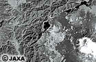
Image Backward
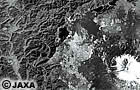
Image at Nadir
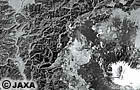
Image Forward
|
Above image was extracted by PRISM on 2006/02/14 10:30.
Altitude information is calculated through those images on the right, then pile PRISM
Image at Nadir to make an bird’s eye view.
*This view displays altitude higher in twice.
The Image also shows Kofu-Basin where detailed roads and rivers appear, at the same time, Lake Motosu on the right, then Mt. Fuji covered with snow and Fuji Subaru Line goes to the summit are clearly seen.
More details of the image here
PRISM Major Characteristics
| Number of Bands |
1 (Panchromatic) |
Wavelength |
0.52 to 0.77 micrometers |
Number of Optics |
3 (Nadir; Forward; Backward) |
Base-to-Height ratio |
1.0 (between Forward and Backward view) |
Spatial Resolution |
2.5m (at Nadir) |
Swath Width |
70km (Nadir only) / 35km (Triplet mode) |
S/N |
>70 |
MTF |
>0.2 |
Number of Detectors |
28000 / band (Swath Width 70km)
14000 / band (Swath Width 35km) |
Pointing Angle |
-1.5 to +1.5 degrees(Triplet Mode, Cross-track direction) |
Bit Length |
8 bits |
Note: PRISM cannot observe the areas beyond 82 degree north latitude and 82 degree south latitude.
| Observation Modes |
Mode 1 |
Triplet observation mode using Forward, Nadir, and Backward views (Swath width is 35km) |
Mode 2 |
Nadir (70km) + Backward (35km) |
Mode 3 |
Nadir (70km) |
Mode 4 |
Nadir (35km) + Forward (35km) |
Mode 5 |
Nadir (35km) + Backward (35km) |
Mode 6 |
Forward (35km) + Backward (35km) |
Mode 7 |
Nadir (35km) |
Mode 8 |
Forward (35km) |
Mode 9 |
Backward (35km) |